Prestige Bannerghatta Road Address and Setting
| Address detail | Prestige Bannerghatta Road |
|---|---|
| Survey numbers | Survey No. 93/1 and 94 (part) |
| Village | Lakshmipura |
| Hobli and taluk | Jigani hobli, Anekal taluk |
| City and PIN | Bengaluru 560083 |
| Access | Off Bannerghatta Road, about 0.2 km from the road |
| Neighbour | The NMIMS Bengaluru campus, next door |
On paper, Prestige Bannerghatta Road is in Anekal taluk, Karnataka, in the Jigani hobli; day to day it belongs to the Lakshmipura and Bannerghatta Road belt, which is the address its name stands for. Kalkere village on Bannerghatta Road is about 1.3 km away, Bannerghatta village about 2.0 km, and Lakshmipura Lake about 1.1 km by road. Area 83 resort is about 5.4 km away by road.
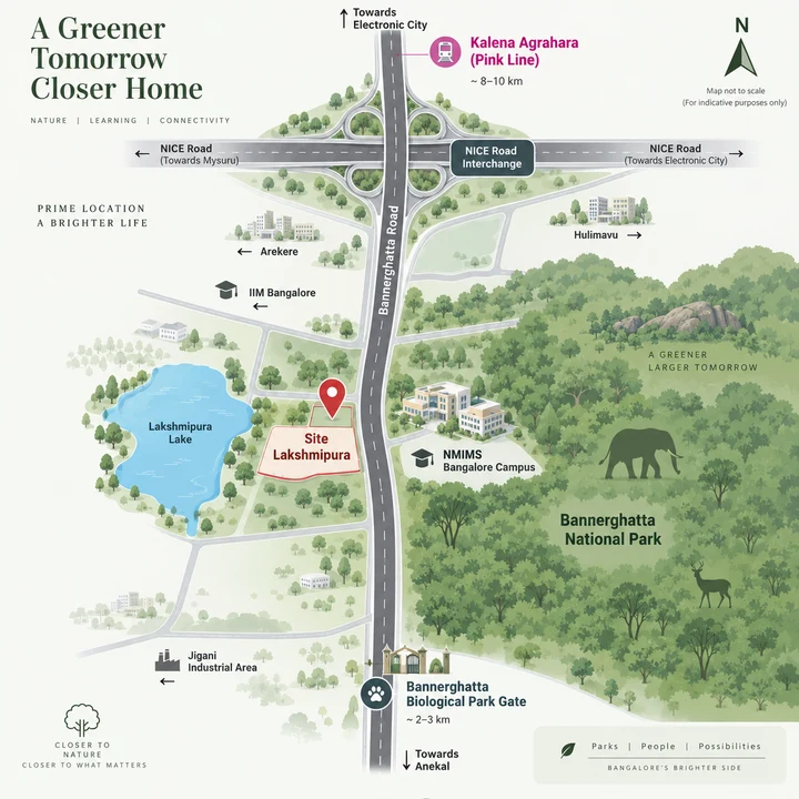
Prestige Bannerghatta Road Road Connectivity
Bannerghatta Road (SH-87), about 0.2 km from the site, is the main route out of the community. Heading north, it passes Gottigere (about 3.9 km), Kalena Agrahara (about 4.9 km) and Hulimavu (about 7.0 km), reaches Hulimavu Gate (about 7.3 km) and continues towards Central Silk Board junction, about 13 km away.
The nearest ring-road access is the NICE Road interchange at Bannerghatta Road, about 3.1 km. From there, NICE Road links the site to Hosur Road for Electronic City and to Kanakapura Road for the south-west of the city. That makes it the natural route for anyone commuting east or west rather than into the centre.
For longer trips:
- City centre: MG Road is about 18 km by road.
- Rail: KSR Bengaluru City, about 21 km, is the practical railhead.
- Airport: Kempegowda International Airport is about 52 km, through the city.
- Jigani and Anekal: Jigani is about 8.9 km and Anekal town about 21 km.
- Bus: the nearest bus terminal is the Bannerghatta BMTC bus stand at the Biological Park gate, about 3.4 km.
These are road distances, not travel times. Bannerghatta Road carries heavy peak-hour traffic, so drive your own commute at the hour you would make it before you decide.
Prestige Bannerghatta Road Metro Access
The nearest metro station will be Kalena Agrahara on the Pink Line, about 5.5 km by road; as at 24 September 2026 the elevated section is built and awaiting its final safety clearance, and is expected to open in 2026. Hulimavu, the next station on the same section, is about 6.6 km. Kalena Agrahara is the southern end of the Pink Line. There is no separate Gottigere station, so read any listing that mentions one as Kalena Agrahara.
The nearest station running today is Konanakunte Cross (Green Line, about 9.5 km by road). Jayadeva Hospital (Yellow Line, about 10.7 km) is the direct run north along Bannerghatta Road and a future Pink Line interchange. The Yellow Line has been operational since August 2025. The Pink Line's underground section, Dairy Circle to Nagawara, is under construction and expected in 2027.
| Station | Line | Road distance | Status as at 24 September 2026 |
|---|---|---|---|
| Kalena Agrahara | Pink Line | about 5.5 km | Built and awaiting its final safety clearance; expected to open in 2026 |
| Hulimavu | Pink Line | about 6.6 km | Same section; expected to open in 2026 |
| Konanakunte Cross | Green Line | about 9.5 km | Operational |
| Jayadeva Hospital | Yellow Line (future Pink Line interchange) | about 10.7 km | Operational |
| Silk Institute | Green Line | about 11.6 km | Operational |
| Electronic City | Yellow Line | about 14 km | Operational |
No metro line has been sanctioned to Bannerghatta, Lakshmipura or Jigani, so the first stretch from Prestige Bannerghatta Road to any station will stay a road journey.
Workplaces near Prestige Bannerghatta Road
Prestige Bannerghatta Road keeps several job clusters within reach by road. The Bannerghatta Road offices are the shortest commute, almost all of it along Bannerghatta Road itself: Salarpuria Symbiosys is about 7.4 km and RMZ Futura about 8.3 km.
- Jigani: the Jigani Industrial Area (KIADB) is about 9.7 km.
- Electronic City: Wipro is about 11.2 km and the Infosys campus about 15 km.
- Bommasandra: the Bommasandra Industrial Area is about 19 km.
- Outer Ring Road: Central Silk Board junction, the gateway to it, is about 13 km.
Schools and Colleges near Prestige Bannerghatta Road
Families at Prestige Bannerghatta Road have schools close by: those within about 2 km by road include Sudarshan Vidhya Mandira (CBSE), about 1.6 km, and Ryan International School, under 2 km. Further along are Sarala Birla Academy (about 2.7 km), Sherwood High School (about 3.0 km), Greenwood High, Bannerghatta (about 3.7 km), Carmel Academy (about 4.6 km) and Delhi Public School Bangalore South (about 9.8 km).
For higher education, the NMIMS Bengaluru campus is next door, about 0.4 km. AMC Engineering College is about 1.7 km, the Christ University Bannerghatta Road campus about 7.2 km and IIM Bangalore about 9.1 km. Check admissions, curriculum and school-bus routes with each school directly.
Hospitals near Prestige Bannerghatta Road
For everyday healthcare, Banashankari Hospital on Bannerghatta Road is about 2.7 km by road from the site. Fosa Humanitarian Hospital is about 1.8 km; confirm the services it offers before you rely on it. Vijayashree Hospitals in Gottigere is about 4.0 km.
For specialist care, Narayana Nethralaya on Bannerghatta Road is about 6.3 km, and Apollo Hospital and Fortis Hospital, both on Bannerghatta Road, are about 8.5 km and 8.7 km. Narayana Health City at Bommasandra is about 17 km. Before you move in, find out which hospital near you handles emergencies at night and save the route.
Shopping and Leisure near Prestige Bannerghatta Road
Weekends at Prestige Bannerghatta Road can start at the park. The main gate of Bannerghatta Biological Park is about 3.4 km by road. The safari start point and the Wildlife Rescue and Rehabilitation Centre are each about 3.6 km, and the Bannerghatta Butterfly Park about 3.9 km. Lakshmipura Lake is about 1.1 km away and Area 83 resort about 5.4 km. The amenities page covers the park lifestyle in more detail.
For the weekly shop, DMart, Gottigere, is about 3.5 km by road; the nearest mall is Royal Meenakshi Mall, about 6.4 km. Centro Mall on Bannerghatta Road is about 8.0 km, the Forum mall at Prestige Falcon City on Kanakapura Road about 9.4 km and Nexus Vega City about 10.4 km.
Prestige Bannerghatta Road Distance Table
Here is everything around Prestige Bannerghatta Road in one table, so you can check your own routine against it. Each figure is a road distance from the site, rounded, not a straight line and not a travel time.
| Place | Category | Road distance |
|---|---|---|
| Bannerghatta Road (SH-87) | Road | about 0.2 km |
| NMIMS Bengaluru campus | College | about 0.4 km (next door) |
| Lakshmipura Lake | Nature | about 1.1 km |
| Kalkere village (Bannerghatta Road) | Locality | about 1.3 km |
| Sudarshan Vidhya Mandira (CBSE) | School | about 1.6 km |
| Fosa Humanitarian Hospital | Hospital | about 1.8 km |
| Ryan International School | School | under 2 km |
| Bannerghatta village | Locality | about 2.0 km |
| Banashankari Hospital, Bannerghatta Road | Hospital | about 2.7 km |
| Prestige Park Square (completed Prestige community) | Prestige nearby | about 2.8 km |
| NICE Road interchange at Bannerghatta Road | Road | about 3.1 km |
| Bannerghatta Biological Park main gate / BMTC bus stand | Landmark / bus | about 3.4 km |
| DMart, Gottigere | Retail | about 3.5 km |
| Bannerghatta safari start point | Landmark | about 3.6 km |
| Greenwood High, Bannerghatta | School | about 3.7 km |
| Gottigere | Locality | about 3.9 km |
| Bannerghatta Butterfly Park | Landmark | about 3.9 km |
| Area 83 resort | Landmark | about 5.4 km |
| Kalena Agrahara metro, Pink Line | Metro | about 5.5 km (as at 24 September 2026, built and awaiting its final safety clearance; expected to open in 2026) |
| Narayana Nethralaya, Bannerghatta Road | Hospital | about 6.3 km |
| Royal Meenakshi Mall | Retail | about 6.4 km |
| Christ University, Bannerghatta Road campus | College | about 7.2 km |
| Salarpuria Symbiosys, Bannerghatta Road | Work | about 7.4 km |
| RMZ Futura, Bannerghatta Road | Work | about 8.3 km |
| Apollo Hospital, Bannerghatta Road | Hospital | about 8.5 km |
| Fortis Hospital, Bannerghatta Road | Hospital | about 8.7 km |
| Jigani | Locality | about 8.9 km |
| Forum mall at Prestige Falcon City, Kanakapura Road | Retail | about 9.4 km |
| Konanakunte Cross metro, Green Line | Metro | about 9.5 km (operational) |
| Jigani Industrial Area (KIADB) | Work | about 9.7 km |
| Jayadeva Hospital metro, Yellow Line | Metro | about 10.7 km (operational) |
| Central Silk Board junction | Road | about 13 km |
| Infosys campus, Electronic City | Work | about 15 km |
| KSR Bengaluru City railway station | Rail | about 21 km |
| Kempegowda International Airport | Airport | about 52 km (through the city) |
See how the six towers sit on the land on the master plan page, read the project's status on the overview, or find quick answers in the FAQs.
Prestige Bannerghatta Road Location FAQs
Is Prestige Bannerghatta Road right on Bannerghatta Road?
Not quite: it sits at Lakshmipura, about 0.2 km off Bannerghatta Road, at the green southern end of the road, past Kalena Agrahara and Gottigere. By road it is about 3.1 km south of the NICE Road interchange at Bannerghatta Road.
Is Prestige Bannerghatta Road in Anekal?
Yes. Prestige Bannerghatta Road is in Lakshmipura village, Jigani hobli, Anekal taluk, Bengaluru Urban, with the PIN code 560083. Jigani town is about 8.9 km by road, while the site itself sits off Bannerghatta Road, about 3.1 km south of the NICE Road interchange.
How far is Area 83 from Prestige Bannerghatta Road?
Area 83 resort is about 5.4 km from Prestige Bannerghatta Road by road. The resort is a landmark of the wider area rather than a neighbour of the site, which is at Lakshmipura, off Bannerghatta Road. Closer to home, the main gate of Bannerghatta Biological Park is about 3.4 km by road.
Is there a metro station near Prestige Bannerghatta Road?
The nearest station will be Kalena Agrahara, the southern end of the Pink Line on Bannerghatta Road, about 5.5 km by road. As at 24 September 2026, the elevated section is built and awaiting its final safety clearance, and is expected to open in 2026. The nearest station running today is Konanakunte Cross on the Green Line, about 9.5 km by road, and Jayadeva Hospital on the Yellow Line, about 10.7 km, is the direct run north along Bannerghatta Road.
How far are Jigani, Electronic City and the airport from Prestige Bannerghatta Road?
By road, Jigani is about 8.9 km and the Jigani Industrial Area about 9.7 km, the Infosys campus in Electronic City about 15 km, and Central Silk Board about 13 km. Kempegowda International Airport is about 52 km through the city. The NICE Road interchange at Bannerghatta Road, about 3.1 km away, links the site to Hosur Road and Kanakapura Road.
Which schools and hospitals are near Prestige Bannerghatta Road?
Sudarshan Vidhya Mandira (CBSE) is about 1.6 km by road, Ryan International School under 2 km and Greenwood High about 3.7 km, and the NMIMS Bengaluru campus is next door. For healthcare, Banashankari Hospital on Bannerghatta Road is about 2.7 km, Narayana Nethralaya about 6.3 km, and Apollo and Fortis on Bannerghatta Road about 8.5 km and 8.7 km. A same-developer shortlist can feel simpler than it really is; Prestige Park Street keeps attention on how each Bengaluru address solves a different routine, budget, and documentation question.